Research
| home | research | graduate students | publications | C.V. |
Scarborough College Coastal Research Group (SCCRG)
The Scarborough College Coastal Research Group (SCCRG) was formed at the Scarborough Campus of the University of Toronto in 1970 to carry out pure and applied research in Coastal Dynamics. The Group provides both undergraduate and graduate training and has strong research links with a number of other University-based researchers, as well as with the Federal Government Research Agency responsible for coastal science (Institute of Marine Dynamics, National Research Council of Canada). Brian Greenwood currently heads the Group which is funded by grants from the Natural Sciences and Engineering Research Council of Canada, the Danish Natural Sciences Research Council and by research contracts from industry and government both in Canada and abroad. Materials and facilities to support laboratory experimentation is provided by the National Research Council of Canada through the Institute for Marine Dynamics.
Fundamental Research is centred on:
(a) marine and lacustrine hydrodynamics and sediment dynamics
(b) the morphodynamic response of the shoreface to sediment transport processesApplied Research is centred on:
(a) physical environmental impact assessment in the coastal zone in Canada and abroad
(b) the implication of engineering structures for sediment transport processes and coastal erosion and sedimentation.The strength of the Group lies in field and laboratory experimentation on sediment transport and the morphodynamic response of the shoreface at small to intermediate spatial and temporal scales as well as modelling at intermediate to large spatial and temporal scales. Examples of continuing research projects are:
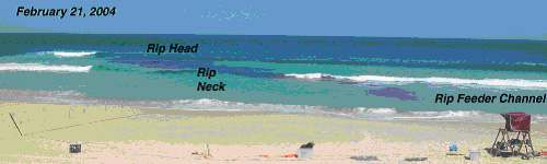
I Rip Current Dynamics
B. Greenwood (SCCRG) R.W. Brander (University of New South Wales, Australia), M. Hughes (University of Sydney, Australia) T. Baldock (University of Queensland, Australia)
Tracing turbulent dispersion patterns in a near shore rip circulation cell.A field experimental study to understand and explain: (a) the observed pulsing of rip flows; (b) the temporal & spatial nature of infragravity energy in rips; (c) the temporal variability of the vertical structure of rip currents in the neck & feeder; (d) the sediment transport along a rip sytem; (e) the link between set-up gradients and rip forcing; (f) the role played by topography and the tide in rip flow. The ultimate aim is to test the standard model of rip cell circulation.
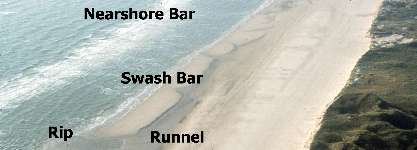
II Long Wave Sediment Transport and Nearshore Morphology
B. Greenwood (SCCRG), T. Aagaard (University of Copenhagen, Denmark)
Intertidal swashbars with runnels and a sub-tidal nearshore bar covered with breaking waves, Skallingen, Denmark. (click for full image)
Dune backed foreshore with intertidal swash bars, runnels and rip current channels, Skallingen, Denmark. (click for full image)The role of forced and free long waves in nearshore sediment transport and the evolution of nearshore morphology is being investigated using detailed field measurements of waves, near-bed horizontal velocities and suspended sediment concentrations. Experimental sites in the Great Lakes and Maritime Provinces of Canada are being investigated as well as a site on the Danish North Sea coast; these areas exhibit groupy incident wave fields and well-developed barred shoreface profiles.
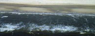
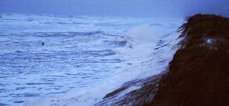
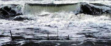
III Morphodynamics of Storm Surge Shorelines
J. Nielsen, N. Nielsen, C. Christiansen & T. Aagaard (University of Copenhagen, Denmark), B. Greenwood (SCCRG)
Reflected incident waves and dune cliffing during a storm surge on the Skallingen Barrier, Denmark. (click for full image)
Energetic surf covers the foreshore at the height of a westerly storm with significant surging, Skallingen, Denmark. (click for full image)Large-scale field experiments are being used to determine sediment flux under storm surges in the Southern North Sea. The goal is understand the nearshore sediment exchanges that lead to rapid dune and shoreline recession on this micro-tidal, multiple barred coastline.
IV Sediment Transport in Wave-current Boundary Layers
B. Greenwood, C. Boldy, N. Sela, Z. Xu, (SCCRG), A.J. Bowen (Dalhousie University), A.E. Hay (Memorial University of Newfoundland), J. Doering (University of Manitoba), P.D. Osborne (University of Auckland, N.Z.) Cooperative field experiments in the Great Lakes and Maritimes have been aimed at understanding the fundamental mechanics of sediment transport under combined wave-current flows by making direct measurements within the wave-current boundary layer. Sensors have been developed to examine the fluid and sediment behaviour in detail within the lowest 0.50 m of the water column in natural nearshore zones, to relate such behaviour to the bottom boundary dynamics and to apply existing models and develop new models to explain the dynamics.
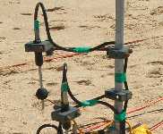
Instrument pod (click for full image and details)V Numerical Modelling of Time-averaged Sediment Transport
B. Greenwood, C. Boldy (SCCRG), D. McGillivray (Private Consultant)The aim of this research is to establish a computer simulation model to predict the long term, time-averaged sediment transport patterns for large sections of shoreline, such as the Toronto Waterfront, and to calibrate the model with field observations. The model is being used to assess the impact of artificial structures on the sediment transport system.
VI Bedforms under Waves
B. Greenwood, (SCCRG), D.H. Willis, (Private Consultant), M. Davies, G. Mogridge (Institute for Marine Dynamics (former Institute for Engineering in the Canadian Environment, National Research Council of Canada), C. Vincent (University of East Anglia, U.K.), P.D. Osborne (University of Auckland, N.Z.)
Cooperative research is aimed at improving our understanding of the interaction between wave-induced currents, sediment entrainment and transport and bed roughness using controlled, large-scale experiments in a both a multi-directional wave basin and a 100-m long wave flume. Both natural and synthetic wave spectra are simulated and a range of grain sizes have been deployed. Cross-calibrations between two bed profilers (HRRTS III developed by SCCRG , a third generation High Resolution Remote Tracking Sonar and Provo, a bed profiler produced by Delft Hydraulics, using electrical resistivity principles) is an attempt to refine a sensor for measurement of micro-topography in the field.
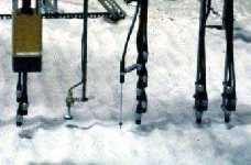
Measuring suspended sediment transport and bedform evolution (click for full image)VII Assessment of the Impacts of a Hydropower Dam on the Cunene River, (Angola/Namibia)
B. Greenwood (SCCRG), L. Strömquist (University of Uppsala, Sweden) SWEDPOWER AB, NORCONSULT International A.S., Burmeister & Partners, SOAPRO
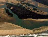
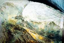
Cunene Delta and fronting littoral drift barrier
(click for full image)
Satellite image of the lower Cunene River
(click for full image)
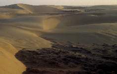
Barchan Dunes of the Engo-Cunene sand Sea
(click for full image)This applied coastal research project is a component of a larger project to assess the impact of various water and sediment discharge scenarios associated with Dam construction and operation associated with hydroelectric power. The emphasis is upon physical impacts upon the braided delta and coastal barrier system at the mouth of the Cunene River.